Online Mapping Tools for Your Ride
An Overview of What Forgotten Roads Uses
Previous posts have touched on some of the map- and route-related tooling and services available for free online, that can help map out your ride. We'll mention them again here, but also – and more importantly – introduce you to to a free service we haven't covered yet, one that we now depend upon heavily for recording our tracks across the country.
OpenStreetMap
From the site's About page:
OpenStreetMap is built by a community of mappers that contribute and maintain data about roads, trails, cafes, railway stations, and much more, all over the world.
OpenStreetMap allows you to upload limited forms of .kml files; depending upon your needs, it could be all you're looking for.
OpenSourceService
OpenRouteService utilizes the data from OpenStreetMap to help users define and generate multi-destination map routes taking into consideration numerous modes of transportation. It also provides for a greater number of road types your route should ignore (e.g., unpaved, fords, tracks).
Like OpenStreetMap, OpenRouteService lets you upload files. It is not as strict in how it parses .kml as OpenStreetMap but we have found issues (bugs) in rendering routes that cause a displayed map to not always match the exact data in the uploaded file. This was a show-stopper for us, but maybe not for others.
Depending upon what you wish to accomplish, you also may need to convert your track or trip files from one format to another. We've run into a few minor rough edges there, but serious.
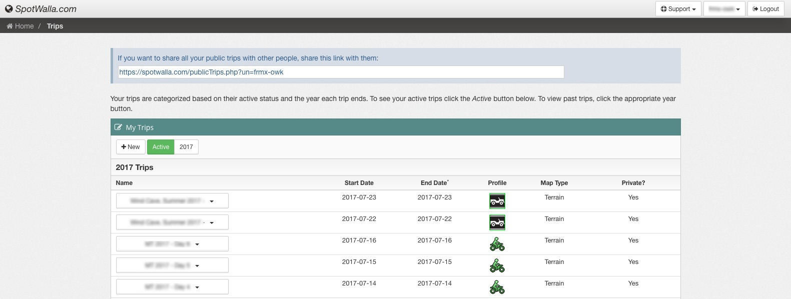
SpotWalla
Spotwalla is our golden child at FRMX: we use an iOS app called SWConnect that was originally designed for use with RVs. The Android app for SpotWalla is called Bubbler GPS and seems quite nice (putting the iOS app to shame, some say). We first found out about SpotWalla when oubiwann met 2ringbike in a Fargo campground as 2ringbike was preparing to set out on his lower-48 ride.
While the SpotWalla service was nice and usable, we almost gave up when we couldn't get SWConnect to make any more frequent updates than every 5 minutes. However, after some digging online we found instructions from the author of SWConnect. His recommendation was to use overlays.
To do this, you set up a trip as usual on the SpotWalla site (for a certain day or range of days). These will be the updates that are, by default, will be sent every 5 minutes. Then, when you're ready to start your trip, open up SWConnect on the iPhone:
- Touch "Application Setup"
- Log in to SpotWalla
- Select the device
- Enable track overlay
- Optionally, enable auto track mode
- Touch "Return to Main Screen"
- Touch "Enable Tracking"
That should do it.
What this does is:
- Start sending the large "spot" messages to SpotWalls, every 5 minutesassociated with whatever trip you created for the current date and time(range),
- Creates a new track for the current date/time
- Batches GPS lat/long data in small messages to SpotWalla
Both can later be downloaded as .kml files and viewed together in as two layers in a single map for any mapping software or service that supports this (many do).
Google "My Maps"
The Google "My Maps" about page doesn't really say much about the product, but basically it allows you to create and share customized maps. Really, the only driver for Forgotten Roads was "can we completely stylize these maps?". The answer was "yes", so we used it.
The additional benefits really make our lives easy, though:
- Quickly upload SpotWalla
.kmlfiles, and thus - Assemble multiple trips and tracks into a single map
- Easily customize the colors of tracks
We've got a whole slew of blog posts in the pipeline that make extensive use of SpotWalla data and "My Maps" to provide trip maps detailing our routes. We couldn't be writing about what we do and how we do it as effectively without these two tools.
Online Topographic Maps
Some of us at FRMX are land-nav nuts, and there's no substitute for a good topo map. In 2009 USGS started a new project to generate topographical maps from 100% digital sources. In all honesty, these don't even compare to the originals (well, the ones published by USGS from 1947 through 1992).
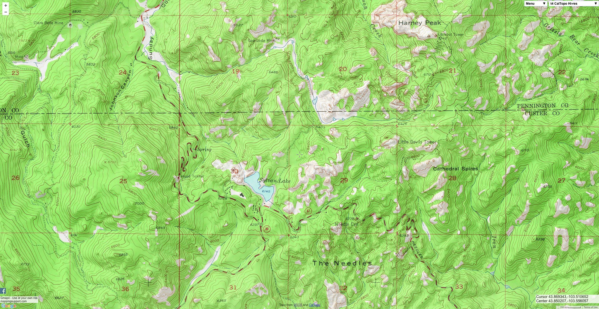
After downloading a whole slew of the new ones in .pdf format and experiencing acute disappointment, we were on the hunt for good online topo maps. The search didn't take long, though: we quickly found (and then even more quickly fell in love with) gmap4 (see the fullscreen version). There's so much to say about this tool, and too little room (this post is already getting a bit long). This is a phenomenal project, and we all hope people continue to donate to it, so that it can continue to survive.
Here's a screenshot of gmap4 that captures the highest peak in the Black Hills as well as some of the best riding in the region:
Summary
This should give you everything you need to get started creating your own ride maps, complete with the GPS info that your device is recording along the way. If we could only pick one, though, it'd have to be SpotWalla.
Have a great adventure! 🛣